
This example demonstrates the new water balance presentation with a focus on Wetlands. You can download the model from this link.
In this model, there are two Standhyd components and one Nashyd component. NHYD 1 and NHYD 2 flow into Addhyd 4, which then directs its outflow to a Wetland (NHYD 9). The wetland has a stage-discharge curve as its outlet type.
Once the model is set up, run the simulation to generate the water balance results.
Interpreting the Water Balance Window
After running the simulation, the Water Balance window becomes available for the wetland.
To view the results:
- Select the Wetland (NHYD 9).
- In the Simulation Table, click on the Water Balance icon.
Year Tab
The Water Balance window contains tabs for Year, Month, and Season. This explanation focuses on the Year tab, though the interpretation applies similarly to the other tabs.
Note: All values are shown in cubic meters (m³).
- Precipitation: Total volume of rainfall directly falling on the wetland.
- Wetland Inflow: Surface runoff received from upstream components (e.g., Addhyd 4).
- ET (Evapotranspiration): Volume of water lost to the atmosphere—an output from the system.
- Wetland Seepage: Represents groundwater exchange. If the value is positive, it indicates water leaving the wetland into the groundwater. If negative, it indicates groundwater entering the wetland.
- Wetland Outflow: Surface water exiting the wetland through the defined outlet.
- ΔStorage: Net change in stored water within the wetland.
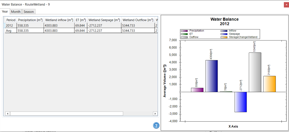
ΔStorage = Precipitation + Wetland inflow – ET – Seepage – Wetland Outflow = 558.335 + 4303.167 – 69.844 – (-2707.685) – 5338.702 = 2160.641 m³
Important Note 1: The area used for calculating water balance (if applicable) is the maximum area defined in the Depth-Area Curve.
In this example, the maximum area is 12,718.34 m² or 1.2718 ha.
- For outlet types like Stage Discharge Curve, Storage Indication, Specific, and Weir, VO uses the maximum area from the depth-area curve for water balance calculations.
- If the outlet is an Orifice, the water balance uses the area defined in the orifice’s Area property.
Addhyd 8 – With Wetland at Upstream
Now, select Addhyd 8, which has a wetland upstream.
- Precipitation, ET, GWI, Runoff, and ΔStorage are totals from all upstreams, including subcatchments and the wetland.
- INFIL represents the cumulative infiltration from upstream.

In this example, the GWI value is negative because it represents the combined groundwater infiltration from both the upstream subcatchments and the wetland’s seepage. Since the groundwater level is higher than the wetland water table, groundwater flows into the wetland, resulting in negative seepage (i.e., water entering the wetland).