
For model calibration, a few sensitive parameters may need to be adjusted several times before a good result can be achieved. The adjustment usually comes with a percentage change. To assist on this process, the Calibrate Commands tool can be used. It allows users to change parameters of different hydrologic objects at once.
The Calibrate Commands tool can select hydrologic objects in a sub-area. The sub-area can be all hydrologic objects 1) upstream of a given object or 2) between several objects. This is very useful in multi-site calibration when the watershed needs to be separated to sub-areas by flow monitoring stations.
To use the Calibrate Commands tool:
1. Select appropriate hydrologic objects.
a. To only update selected hydrologic objects, select all of them;
b. To update hydrologic objects upstream of a certain point, select the hydrologic object corresponding to that point, which is usually the AddHyd corresponding to the flow monitoring station.
c. To update hydrologic objects between one point to another, select the hydrologic object corresponding to the downstream point.
2. Click the Calibrate Commands button  in Simulation tab.
3. The Command Calibration window will appear.
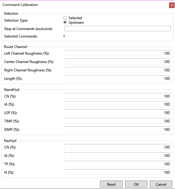
4. Set up the selection in the Selection portion on the top.
a. To only update selected hydrologic objects, choose Selected;
b. To update hydrologic objects upstream of a certain point, choose Upstream;
c. To update hydrologic objects between one point to another, choose Upstream and enter the NHYD of the most upstream hydrologic objects in Stop at Commands (Exclusive) text box. Multiple NHYD should be separated by comma.
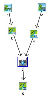
For the model given below, the AddHyd 5 is selected. The updated hydrologic objects with the three options are given below.
a. Only AddHyd 5 will be updated if Selected is used;
b. NasHyd 1 & 2, RouteChannel 3 & 4 and AddHyd 5 will be updated if Upstream is used.
c. RouteChannel 3&4 and AddHyd 5 will be updated if Upstream is used and Stop at Commands (Exclusive) is set to 3, 4.
The number of updated hydrologic objects will be given at Selected Commands in Selection section. Note it is not always the number of selected hydrologic objects.
5. Specify the percentage change for RouteChannel, StandHyd and NasHyd in the three sections below the Selection section. All common parameters are listed and the default value is 100. To decrease the parameter values, enter a value smaller than 100 (e.g. 80). Otherwise, enter a value larger than 100 (e.g. 120).
6. Click OK button to apply the changes.