
To download a Digital Elevation Model (DEM) file, navigate to the GIS tab and locate the “Download DEM” option.

In the opened window, you must first select a dataset from the available options:
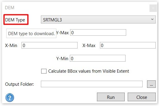
SRTMGL3 (SRTM GL3 90m)
SRTMGL1 (SRTM GL1 30m)
SRTMGL1_E (SRTM GL1 Ellipsoidal 30m)
AW3D30 (ALOS World 3D 30m)
AW3D30_E (ALOS World 3D Ellipsoidal, 30m)
SRTM15Plus (Global Bathymetry SRTM15+ V2.1)
NASADEM (NASADEM Global DEM)
COP30 (Copernicus Global DSM 30m)
COP90 (Copernicus Global DSM 90m)
EU_DTM (DTM 30m)
GEDI_L3 (DTM 1000m)
If you know the geographical coordinate system of the area you wish to download, you can assign the maximum and minimum values for the X and Y coordinates to download the corresponding DEM. Alternatively, you can easily use the “Calculate BBox Values From Visible Extent” option. This will allow the software to automatically extract the coordinate system from the Map View.
After setting the coordinates, specify the location for the Output Folder where you want to save the downloaded DEM.
Click on the “Run” button to initiate the DEM download process.
Please note that the download time may vary based on your internet speed. Once the DEM file is successfully downloaded, you will receive a confirmation message, and you can view the downloaded DEM under the imported layer.