
The impervious depression storage, DPSI, should be set to an appropriate value for the representative impervious surface. For roads, driveways, and roofs, this value is typically between 0.8 mm and 1.5 mm.
The impervious slope, SLPI, is the average slope of impervious areas. This is not the catchment slope from highest point to lowest point, but an average when considering only the impervious areas. For example, if the catchment consists of a residential subdivision, this value would represent the average slope of the impervious road surfaces. In this example the slope would not be less than whatever the municipal minimum is. Typically, SLPI ranges between 0.5 to 2.0.
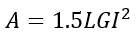
The impervious length, LGI, is one of the most important parameters for modeling urban catchments. A common mistake when modeling ungauged urban catchments is to set LGI equal to the measured catchment length. Previous studies by Paul Wisner Associates Inc. have determined that LGI is related to the catchment area based on the following equation:
 (5)
(5)
where:
A = catchment area (![]() )
)
LGI = impervious length (m)
This relationship will yield runoff characteristics similar to those which would be measured. The LGI parameter should only be adjusted from this relationship if the model is being calibrated.
The Manning’s roughness coefficient for impervious surfaces, MNI, should be selected based on channel flow, not sheet flow as in MNP. For example, if the representative impervious surface were a road, then the MNI should be set around 0.013.
For an ungauged urban catchment, the impervious storage coefficient, SCI, should be set to 0, which will let the program determine the storage coefficient.