
RouteChannel is used to route hydrographs through typical channel cross-sections using the Variable Storage Coefficient (VSC) Method. The open channel cross-sections are described with X and Y co-ordinates. The COMPOUNDCHANNEL command in VO6 has been split to calculate channel routing in both a “low flow channel” and “floodplain” portions of the cross section with the routing effects then being combined for the final output. The user can define channel and flood-plain lengths and slopes.
The ROUTECHANNEL and COMPOUNDCHANNEL have an option for Erosion Index calculations. Users could determine erosion threshold flow rate as targets to assess pre and post development conditions.
Other inputs are the average longitudinal slope and the variation of Manning’s roughness coefficient across the width. The hydrologic object computes a rating curve and travel time prior to routing with the VSC method.
| Parameter Name | Description | Default Value |
|---|---|---|
| CHLGTH | Length of channel reach (m or ft) | 500 |
| FPLGTH | Length of floodplain reach (m or ft) | 500 |
| CHSLOPE | Average longitudinal channel slope (%) | 0.2 |
| FPSLOPE | Average flood plain slope (%) | 0.2 |
| VSN | Valley Section Number used for identification and printing purposes. | 1.1 |
| NSEG | Number of segments in the channel cross-section with constant Manning’s roughness coefficients. The channel and floodplain sections of the cross section are defined here. NOTE: The Manning’s roughness coefficient that describes the main channel must be entered as a negative (e.g. –0.025) | 3 |
| ROUGH, SEGDIST | Paired values describing the roughness over the segment distance (X co-ordinate). Each roughness value, ROUGH, is applied over the distance specified by SEGDIST which should also be one of the distance co-ordinates found in DIST/ELEV. SEGDIST has units (m or ft). A maximum of 6 points can be entered. | 1.5, 0.050 4.5, -0.03 6.5, 0.050 |
| DIST/ELEV | Co-ordinates describing the shape of the cross section as (X, Y). A maximum of 20 points can be entered. Units length (mm or ft). 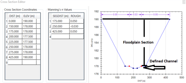 |
0.0, 101.5 1.0, 100.7 1.5, 100.5 2.0, 99.50 3.5, 99.60 4.5, 100.65 6.0, 101.45 |
| Divider | Number of lines in travel time table | 1 |
| Critical flow (m³/s) | Critical flow to calculate erosion index | 0.1 |