
In some cases, model parameters are available in GIS layers. The Calculate LandUse Percentage tool reads the parameter values, calculate the area weighted value if necessary and then assign to catchments LandUse. To use this tool:
- Add the GIS layer that has the parameter information.
- Select catchments whose landuse will be updated. Please select at least one catchment before clicking the tool button to open the tool window.
- Click the Calculate LandUse Percentage button
![]() located in the GIS tab. The Calculate LandUse Percentage Parameter window will appear. Notice that the number of selected catchments is shown at the top of the window.
located in the GIS tab. The Calculate LandUse Percentage Parameter window will appear. Notice that the number of selected catchments is shown at the top of the window. - Choose the Source Layer and the Source Field, where the parameter values will be retrieved. The source layer should be a polygon layer and the source field could be any type. In this case, we choose TRCAcode, which is a field indicating the landuse in the polygon.
- Click the Update button at the bottom of the window. A message window will appear, indicating that the landuse of selected hydrologic objects has been added to water quality data in project manager.
![]()
- The Close button at the bottom of the window can be used to close the window.
 located in the GIS tab. The Calculate LandUse Percentage Parameter window will appear. Notice that the number of selected catchments is shown at the top of the window.
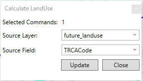
Copyright © 2025 Smart City Water
—
Powered by 