
In some cases, model parameters are available in GIS layers. The Calculate Area Weighted tool reads the parameter values, calculate the area weighted value if necessary and then assign to catchments. The imperviousness (TIMP and XIMP) and initial abstraction are two parameters that can utilize this tool. To use this tool:
- Add the GIS layer that has the parameter information.
- Select catchments whose parameter will be updated. Please select at least one catchment before clicking the tool button to open the tool window.
- Click the Calculate Area Weighted button
![]() located in the GIS tab. The Calculate Area Weighted Parameter window will appear. Notice that the number of selected catchments is shown at the top of the window.
located in the GIS tab. The Calculate Area Weighted Parameter window will appear. Notice that the number of selected catchments is shown at the top of the window. - Choose Parameter to Calculate from the drop-down menu. In this case, only StandHyd parameters are shown here as only StandHyds are selected. We want to use Timp this time.
- Choose the Source Layer and the Source Field, where the parameter values will be retrieved. The source layer should be a polygon layer and the source field can be any type. In this case, we choose OBJECTID.
- Define the field mapping to map all the field values to the desired parameter value.
- Click the Update button at the bottom of the window. A message window will appear, indicating that the parameter of selected hydrologic objects has been updated.
 located in the GIS tab. The Calculate Area Weighted Parameter window will appear. Notice that the number of selected catchments is shown at the top of the window.
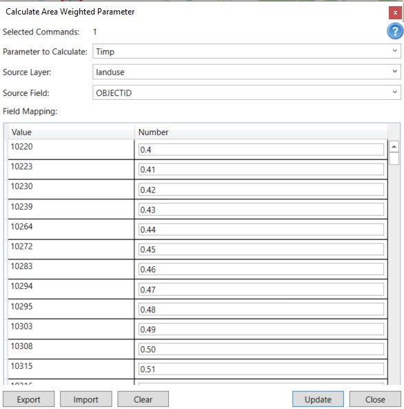
- Similar to the Calculate CN tool, the value mapping can be exported to a file and then imported later using the Export and Import button at the bottom.
- The Clear button at the bottom of the window can be used to clear the lookup table and start all over again.
For each hydrograph, its parameter is calculated by the following equation:
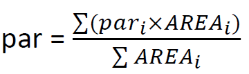
where ![]() is the parameter value of the segment i whose area is
is the parameter value of the segment i whose area is ![]() .
.
Copyright © 2025 Smart City Water
—
Powered by 