
The Raster Clipping tool in VO provides a valuable solution when working with large DEM files but needing to focus on a specific area for analysis. This tool allows you to extract the desired portion of the DEM, significantly improving processing speed and efficiency. To take advantage of this tool, you’ll need a DEM file and a shape file containing the polygon(s) defining the clipping area(s).
Follow the step-by-step instructions below to effectively utilize the Raster Clipping tool:
1. Begin by locating and selecting the “Clip Raster” option within the software’s interface. This will open the Raster Clipping window.

2. Within the Raster Clipping window, you’ll find three essential components: a. “Input Raster”: Choose the DEM file you wish to clip by selecting it from your computer’s file system. b. “Input Vector”: Provide a shape file that contains the polygon(s) defining the desired clipping area. The interior of the polygon(s) will be used for the clipping process. c. “Output Folder”: Specify a destination folder where the resulting clipped raster file will be saved.
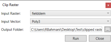
3. Once you’ve set the input raster, input vector, and output folder, click the “Run” button to initiate the clipping process.
4. The software will execute the clipping operation, extracting the desired portion of the DEM. The resulting clipped raster will then be added as a new layer under the “Imported” layer in the map view.
By utilizing the Raster Clipping tool, you gain the ability to focus your analysis on specific regions of interest within large DEM files. This not only enhances processing speed but also enables targeted analysis and improves efficiency when working with extensive datasets.
It is advisable to save your project at this stage to preserve your work and ensure easy access to the clipped raster for future use or further analysis. This way, you can conveniently return to your project, build upon your findings, and conduct additional investigations without the need for repetitive clipping operations.
The Raster Clipping tool in VO empowers you to extract and work with the most relevant portions of your DEM files, streamlining your analysis and enabling more precise and efficient geospatial workflows.