
To run the “Generate Catchments” option under “Rural DEM Processing” and delineate subcatchments in the software, please follow these steps:
1. Click on the “Generate Catchments” button located under the “Rural DEM Processing” section.
2. From the drop-down menu, select the DEM file you want to use for the analysis.
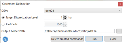
3. Choose either the “Target Discretization Level” or specify the desired number of cells for the subcatchments. For large-scale projects, it is recommended to use higher values to avoid generating small subcatchments.
4. Specify the output folder path where the generated files will be saved. If you have already saved your project, the software will automatically recognize the location. Otherwise, you need to provide a path to save the files.
5. Once you have configured the options, click on the “Run” button to initiate the process.
The software will then generate the flow path, conduits, nodes, and subcatchments based on the selected DEM and parameters. The generated files will be saved in the specified output folder.