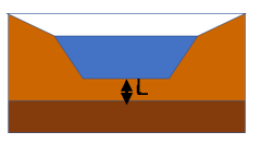
The wetland command in VO is designed to mimic a natural wetland, with a wet storage area surrounded by a dry vegetated area. The storage area and dry area are both dynamic in order represent the flooding and drying out seen in many natural wetlands. The way this works in the model is that the total area = storage area + dry area. When it rains and the storage area begins to fill the surface area of the wet portion of the wetland increases and the dry are decreases.
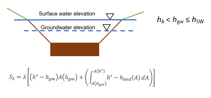
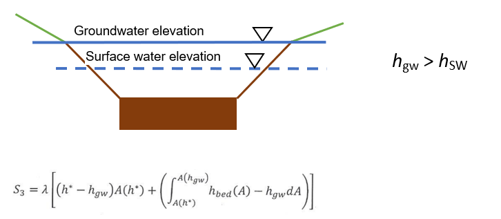
Modeling for the wetland uses the same equations as the NasHyd (dry area) and RouteReservoir (wet area), with the addition of groundwater interaction in the storage area. Groundwater is used as an input to the model and the VO wetland command should not be used to model the impacts of a wetland on the groundwater. The model uses the Darcy equation to calculate the seepage of water into and out of the storage portion of the wetland. Our model can be described in three separate scenarios:
Scenario 1 – maximum recharge, when the groundwater is below the bottom of the wetland

Scenario 2 – reduced recharge, when the groundwater is above the bottom of the wetland but be-low the surface water
Scenario 3 – Discharge, when the groundwater is above the surface water
For the above equations:
hbed Elevation of the bottom of the wetland. If the wetland has multiple pools this value is the lowest elevation in the wetland.
![]() Elevation of the groundwater, provided as an input file.
Elevation of the groundwater, provided as an input file.
h* Elevation of the surface water.
λ Leakage factor = K/L, where:
K is the hydraulic conductivity of the sediment layer at the bottom of the wetland (m/s)
L is the thickness of the of the sediment layer (m)
The leakage factor is a calibration parameter for the wetland routine. When calculating the value to use for the leakage factor you should consider the soil within the top meter to meter and half of soil under the wetland. If the soil under the wetland is not uniform there are two scenarios to consider.
If the If the top soil layer is permeable such as sand, loam or loose organic matter and the lower soil layer is a less permeable layer such as clay use the combined depth of the soils and an average K value.

If the top soil layer is clay or other impermeable soil and the lower soil layer is a more permeable layer such as sand use the depth (L) and K value for the impermeable layer.