
Curve Number (CN) is the most important parameter to determine surface runoff when SCS equation is used. Its value varies for different soil types, land use, and Antecedent Soil Moisture Condition (AMC). The CN for the average antecedent soil condition (CNII) is usually used. Lookup tables have been established for land use, soil hydrological group, and CNII (Table 7-4).
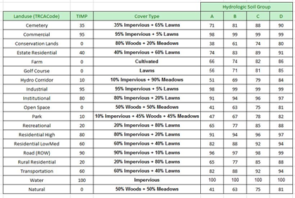
TABLE 7-4 SAMPLE LAND USE, SOIL AND CN LOOKUP TABLE
In most cases, CNII of each catchment is estimated with the land use and soil information and applicable lookup tables. If land use and soil layers are available, GIS software is usually used to conduct the calculation. For catchments covering more than one land use or soil type, an area weighted CNII are usually calculated.
The Calculate CN tool makes the process easier. To use this tool:
- Add soil and land use layers. Make sure the soil layer has the soil hydrologic group data and the land use layer has the land use data.
- Select catchments (StanHyd, NasHyd, WilHyd or ScsHyd) to be updated in Map View or Schematic View. Note that the selected catchments must be assigned to a geometry. If no catchments are selected by users, the tool will run the calculation for each of all the catchments.
- Click the Calculate CN button
![]() in the GIS tab. The Calculate CN window will appear. The window has the left part for soil mapping and the right part for the land use mapping. Note that the number of selected catchments available for CN calculation is shown on the top of the window. If no catchments are selected by users, the number shown is the total number of the catchments.
in the GIS tab. The Calculate CN window will appear. The window has the left part for soil mapping and the right part for the land use mapping. Note that the number of selected catchments available for CN calculation is shown on the top of the window. If no catchments are selected by users, the number shown is the total number of the catchments. - On the left part, choose the soil layer from the Soil Layer list and then choose the Soil Group Field. The soil hydrologic group mapping table will become available, and it automatically maps hydrological group (A, B, C and D) for the soil layer. Users can change the mapping for each soil hydrological group.
- On the right-hand side, choose the Land Use Layer from the layer list and then choose the Land Use Field. Select the CN Table from the drop-down list next to the Mapping. By default, the drop-down menu for Mapping has TRCA, CVC, and TR-55 as options. The land use mapping table will become available, and it automatically maps land use type for the land use layer based on the selected CN table. Users can change the mapping for each land use type.
- Click the Update CN button at the bottom to update the CN based on soil and land use data. A message window will appear indicating that CN of selected hydrologic objects have been updated.
 in the
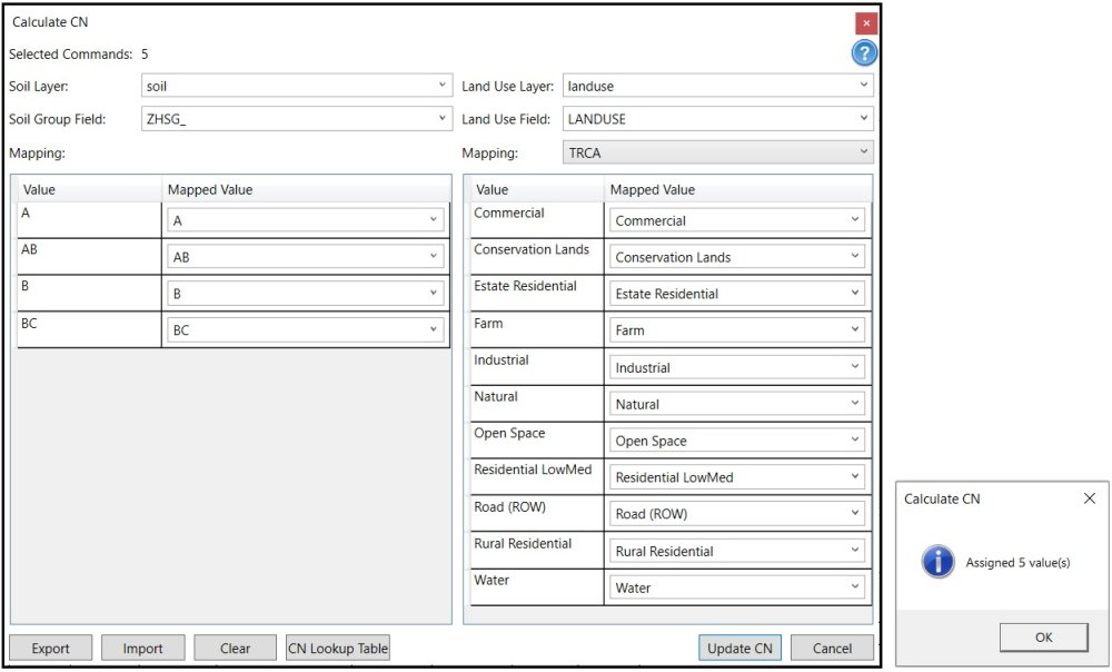
- To export the soil and land use layer mapping information, click the Export button at the left bottom corner to save the mapping information to a file. The saved file can be imported using the Import button.
- The Clear button at the bottom can be used to clear all field mapping information and start all over again.
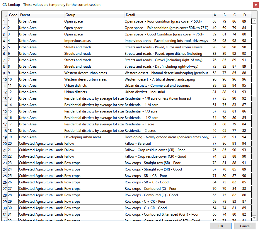
- To see the default CN lookup table, click the CN Lookup Table button. Note that the lookup table is not editable.
For each subcatchment, its CN is calculated by the following equation:
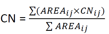
where ![]() is the CN value read from the CN Lookup Table when Soil Type is i and Land Use is j, and
is the CN value read from the CN Lookup Table when Soil Type is i and Land Use is j, and ![]() is the area of the segment ij whose soil type is i and Land Use is j.
is the area of the segment ij whose soil type is i and Land Use is j.