
In hydrological analysis, it is crucial to start with a depressionless Digital Elevation Model (DEM) to ensure accurate results. These steps are essential for tasks such as determining flow directions and accumulations and delineating drainage networks and basins.
Step 1: Launch the Tool To begin, follow these steps:
1. Click on the GIS Tools.
2. Look for the “Sink and Flat Analysis” option under Rural DEM Processing and click on it.

Step 2: Select the DEM
1. In the opened tool interface, locate the dropdown menu in front of the DEM Layer option.
2. Select the desired DEM from the available options.
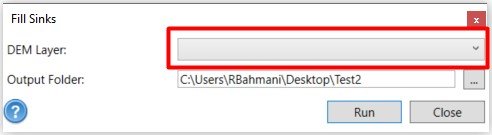
Step 3: Specify the Output Folder
1. Find the Output Folder field in the tool interface.
2. Choose a location where you want to save the generated DEM file. Note: Select a suitable folder to store your output file.
Step 4: Run the Analysis
1. Ensure that all the necessary options are set according to your requirements.
2. Click the “Run” or “Execute” button to initiate the analysis.
3. The tool will perform the Fill and ResolveFlat operations on the selected DEM, creating a depressionless DEM without pits and flat areas.
Remember:
- This option is particularly recommended for large-scale projects or rural areas where flat areas are prevalent.
- Always follow the correct sequence of hydrological tools to achieve accurate results.
- By starting with a depressionless DEM, you can have a high degree of certainty about the quality of your hydrological analysis outcomes.