Use the Imperviousness Calculation tool to calculate the imperviousness percentage of each subcatchments based on user’s input layers like roof layer, road layer, etc.
Before starting to use the tool, add all the necessary layers to the Map by using Add Layer tool. Then, click the Imperviousness Calculation button to open the window as below. Choose the desired layers from the dropdown lists or set proper values for each field.

By using this tool, we have the following definitions. The imperivious area (a_imp) is considered to include disconnected slopped roof, regular parking lot, regular driveway, sidewalk and road. The net area (a_net) is the area by subtracting the original total area by the following areas: flat roof, connected slopped roof, large parking lot, back yard, and reverse driveway. Users can choose to define the imperviousness ratio as either a_imp/a_net or a_imp/a_total.
More details about the algorithm procedure is explained as below:
- Get large parking lot area (a_largeParking) and back yard (a_backYard) based on the layer selected in the dropdown lists of Large Parking Lot and Back Yard fields. Both fields require polygon shapefiles.

- Get roof area (a_roof) for each subcatchment. Then, get slopped roof (a_slp_roof) and flat roof (a_flat_roof) from a_roof.
There are two ways to get a_slp_roof and a_flat_roof:- Use a roof layer. In the Roof Settings section, select Use a roof layer and choose the roof layer from the dropdown list next to it. The roof layer requires polygon shapefile. In the Roof Type field, select the attribute that is used as the indicator for roof type. Click the
![]() button to open a mapping window to map the attribute value used in the shapefile with the value (i.e. SlopedRoof and FlatRoof) used by the software.
button to open a mapping window to map the attribute value used in the shapefile with the value (i.e. SlopedRoof and FlatRoof) used by the software.
![]()
- Use roof ratios. In case that users do not have roof shapefile, select Use a roof ratio to total area and give a ratio (roof_ratio) in the field. In the field Sloped roof ratio to total roof, type a ratio to tell the ratio of sloped roof compared to total roof area (slp_roof_ratio). In this case:
a_slp_roof = a_total x roof_ratio x slp_roof_ratio
a_flat_roof = a_total x roof_ratio x (1-slp_roof_ratio)
![]()
- Use a roof layer. In the Roof Settings section, select Use a roof layer and choose the roof layer from the dropdown list next to it. The roof layer requires polygon shapefile. In the Roof Type field, select the attribute that is used as the indicator for roof type. Click the
 button to open a mapping window to map the attribute value used in the shapefile with the value (i.e. SlopedRoof and FlatRoof) used by the software.

- Get roof connections. There are also two ways to define it:
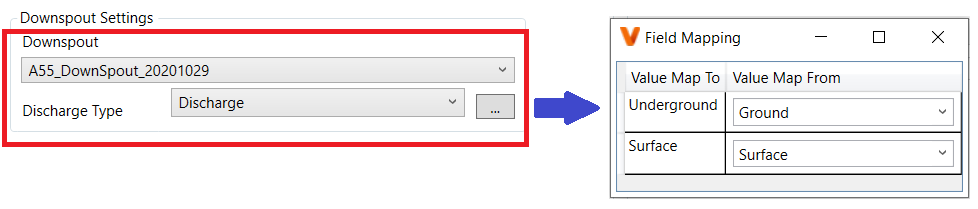
- Use downspout layer. The downspout layer, which is a point shapefile, can tell whether the roof is connected to underground sewer or not. Select the downspout layer from the dropdown list in the Downspout Settings section. In the Discharge Type field, select the attribute that is used as the indicator for discharge type. Click the
![]() button to open a mapping window to map the attribute value used in the shapefile with the value (i.e. Underground and Surface) used by the software. The Underground means being connected to underground sewer, whereas the Surface means being disconnected to sewer and discharged to the surface.
button to open a mapping window to map the attribute value used in the shapefile with the value (i.e. Underground and Surface) used by the software. The Underground means being connected to underground sewer, whereas the Surface means being disconnected to sewer and discharged to the surface.
![]()
Then, the connection ratio (ratio_con) will be calculated as:
ratio_con = (connected_downsprout + ratio_k x indetermine_downspout) / total_downspout,
where, for each subcatchment, total_downspout — the total number of downspout, connected_downsprout — the number of connected downspouts, indetermine_downspout — the number of downspout whose discharge type is not defined, ratio_k — the connection ratio obtained from the whole downspout layer:
ratio_k = total_connected_downspout / total_known_downspout,
where, total_connected_downspout — the total number of connected downspouts from the entire downspout layer, total_known_downspout — the total number of downspouts whose discharge type is defined from the entire downspout layer.
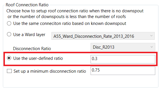
In some subcatchment, the downspout number is unknown, users can choose to Use the same connection ratio based on known downspout (i.e. ratio_k), Use a Ward layer, which is a polygon layer defining disconnection ratio, or Use the user-defined ratio in the Roof Connection Ratio section.
![]()
- Use the user-defined ratio. In case that users do not have downspout layer, leave the Downspout Settings section empty and choose Use the user-defined ratio in the Roof Connection Ratio section.
![]()
If users check on the box Set up a minimum disconnection ratio and give a ratio in the field (user_min_dis_ratio), then:
ratio_con = max (1-user_min_dis_ratio, ratio_con)
- Use downspout layer. The downspout layer, which is a point shapefile, can tell whether the roof is connected to underground sewer or not. Select the downspout layer from the dropdown list in the Downspout Settings section. In the Discharge Type field, select the attribute that is used as the indicator for discharge type. Click the
- Calculate connected sloped roof (a_slp_con) and disconnected slope roof (a_slp_dis):
a_slp_con = ratio_con x a_slp_roof
a_slp_dis = a_slp_roof – a_slp_con - Calculate reverse driveway area (a_dri_rev). Reverse Driveway is a point layer to show there is a reverse driveway. The reverse driveway area (a_dri_rev) is calculated as below:
a_dri_rev = n_dri_rev x a_dri_rev_per_area,
where, n_dri_rev — the number of the Reverse Driveway points in each subcatchment, a_dri_rev_per_area — Area per Reverse Driveway.
![]()
- Calculate the net area as: a_net = a_total – a_largeParking – a_backYard – a_flat_roof – a_slp_con – a_dri_rev
- There are two ways to get impervious area
- Use regular parking lot, sidewalk, road and regular driveway. Select Pervious shape file is unknown in the Options section. Get the Regular Parking Lot area (a_reg_parking), the Sidewalk area (a_sidewalk) and the Road area (a_road) by choosing shapefiles from the dropdown lists. The regular driveway area (a_dri_reg) will be calculated as:
a_dri_reg = a_slp_roof x percent_dri_reg / 100, where, percent_dri_reg — the user’s input of Regular Driveway %.
![]()
- Use pervious area. Select Pervious shape file is known in the Options section. Choose the Pervious Area layer. Check on the box Include Part means only a part of pervious area will be used based on the attribute value.
![]()
- Use regular parking lot, sidewalk, road and regular driveway. Select Pervious shape file is unknown in the Options section. Get the Regular Parking Lot area (a_reg_parking), the Sidewalk area (a_sidewalk) and the Road area (a_road) by choosing shapefiles from the dropdown lists. The regular driveway area (a_dri_reg) will be calculated as:
- Calculate imperviousness ratio
- Update total area with net area. By checking on this box, it means the Area parameter in the Properties tab of subcatchment will be replaced with a_net and % imperv = a_imp / a_net x 100
- Not update total area with net area. By unchecking this box, it means the Area parameter will be the unchanged and % imperv = a_imp / a_total x 100
![]()