
Click the Aquifers button to open the Aquifer Editor window.
| Button | Description |
|---|---|
 |
Add one aquifer |
 |
Delete selected aquifers. Please note to use Ctrl and Shift keys for multiple selection. |
 |
Import a group of aquifers |
| |
Export all the aquifers |
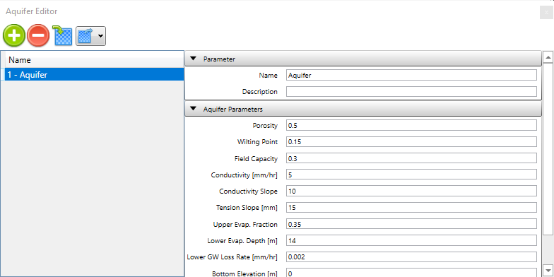
The Aquifer Editor is used when creating or editing an Aquifer object. It includes various data fields:
- Name: A user-assigned name for the aquifer.
- Porosity: The volume of voids compared to the total soil volume (as a volumetric fraction).
- Wilting Point: Soil moisture content at which plants can’t survive (volumetric fraction).
- Field Capacity: Soil moisture content after free water has drained off (volumetric fraction).
- Conductivity: Soil’s saturated hydraulic conductivity (in/hr or mm/hr).
- Conductivity Slope: Average slope of log(conductivity) vs. soil moisture deficit curve (unitless).
- Tension Slope: Average slope of soil tension vs. soil moisture content curve (inches or mm).
- Upper Evaporation Fraction: Fraction of total evaporation available for evapotranspiration in the upper unsaturated zone.
- Lower Evaporation Depth: Maximum depth below the surface for evapotranspiration from the lower saturated zone (ft or m).
- Lower Groundwater Loss Rate: Rate of percolation to deep groundwater when the water table reaches the ground surface (in/hr or mm/hr).
- *Bottom Elevation:*Elevation of the aquifer’s bottom (ft or m).
- Water Table Elevation: Elevation of the water table in the aquifer at the simulation’s start (ft or m).
- Unsaturated Zone Moisture: Moisture content of the unsaturated upper zone of the aquifer at the simulation’s start (volumetric fraction, not exceeding soil porosity).
- Upper Evaporation Pattern: The name of a monthly time pattern used to adjust the Upper Evaporation Fraction for different months of the year (leave blank if not applicable).
Copyright © 2025 Smart City Water
—
Powered by 