
1. Switch to the “Migro-Drainage” tab within the VOSWMM software.
2. From the available options, select “Flow Path” under the “Urban DEM Processing” section.
3. This action will open the “Flow Path Generation” window, which is necessary for generating accurate subcatchments in urban areas.

Note: It is crucial to use a high-resolution DEM file to ensure the accuracy of the subcatchment generation process. A pixel size ranging from 0.3 to 2 meters is recommended for obtaining acceptable results.
4. In the “Flow Path Generation” window, follow these steps:
• Click on the drop-down arrow located in front of the “DEM Raster File” field and select the imported DEM file.
• Optionally, adjust the “Target Discretization Level” or specify the desired number of cells. The default value usually works well for urban areas.
• Check the “Auto-Generate Nodes, Conduits” option to automatically create nodes and conduits.
• Specify an output folder where the generated files will be saved.
5. Review the configuration and settings in the “Flow Path Generation” window to ensure they match your requirements.
6. When you are ready, click the “OK” button to initiate the subcatchment generation process.

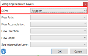
Note: If you want to automatically generate “Invert Elevation” for nodes and conduits, click on “Assign Layer” and select the DEM file to be assigned as the “DEM”.

Note: The time required for generating nodes and subcatchments may vary depending on the scale and resolution of the DEM file.