
 LandMark MUST BE RAN on the primary screen to allow the system to read values over.
Parcel Splits can be initiated from two places:
- Split Utility in LandMark (preferred method)
- MapAnalyzer from the map by editing the layer and selecting the Split icon.
Split from LandMark (the preferred place to start a Split)
Using the Split Utility tool in LandMark allows the following things:
- Automatically generates a new Child Account
- Updates any Ag Land
- Carries over any data from the Parent Account
User can choose to map the Split one of three ways:
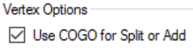
- Rectangular Survey: Used for simple rectangular surveys by legal Ex: Splitting a parcel in half from 29-20N-1E NE/4 to 29-20N-1E E/2 UNCHECK the Use COGO for Split or Add box in Editor Preferences, if splitting by Rectangular Survey.
![]()
- COGO: Used when the Coordinate Geometry (Metes and Bounds) is known. If splitting by COGO, check the box in Editor Preferences.
![]()
- Keyboard: User uses the mouse and/or keyboard arrows to define calls that go directly N, S, E and W UNCHECK the Use COGO for Split or Add box in Editor Preferences, if splitting by Keyboard.
![]()

After starting a split in LandMark, splitting in MapAnalyzer, clicking apply and going back to LandMark my computer appears to freeze. Users now have to HIT Esc (escape) in the LandMark window to cancel the LandMark system from following the map when doing combines or splits. The system may appear locked up, there will be a status bar message in the bottom left corner of the window stating “Watching for Update, Escape to Cancel”. After hitting the Esc key, users may proceed in correcting legal and finishing combine or split.
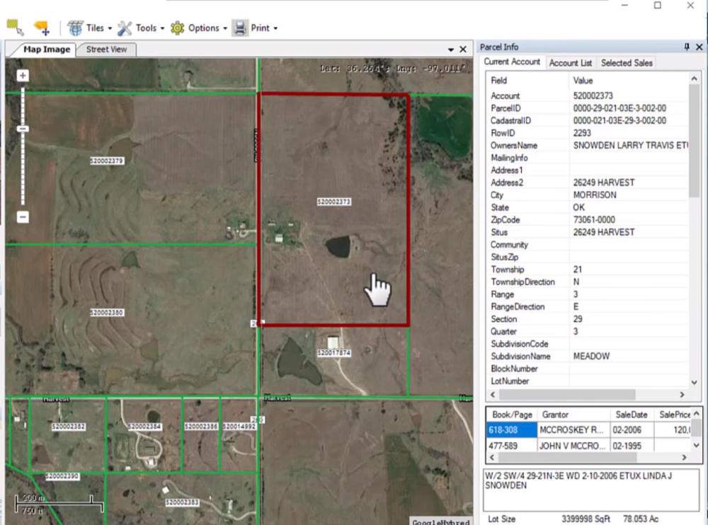
From the parcel file select
Tools- Split
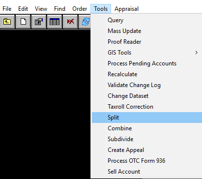
Landmarks Parcel Split Utility will open
Assessment Info Tab
Basic information from your parent and child account will be displayed. The parent parcel information will populated with the data in LandMark.
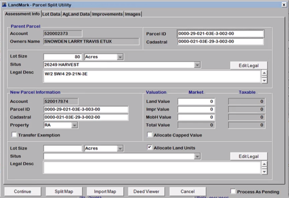
Parent Parcel: basic parent parcel information including Account , Owners Name, Parcel ID, and Cadastral.
User can update parcel information that may change during the split such as updating legal and lot size.
To edit Parent Legal
CLICK in the text box
or
SELECT “Edit Legal” button.
New Parcel Information (Child Account): An account number will already be selected based on the next number in the county’s sequence, the Parcel ID will also be generated. Users can change the parcel ID, cadastral, and property class of the new parcel.
Transfer Exemptions Box: a checked box allows users to transfer any exemptions from the parent.
Valuation can be automatically imputed or will be assigned once the Split is applied on the map (see below).
Allocate Capped Value: There is never a reason to check this box. If box is checked this will allocate the previous value of both accounts and keep them capped.
Lot Size
Allocate Land Units: If box is checked this will automatically take the new parcel’s lot size out of the parent parcel. If the lot size is not given in the deed, MapAnalyzer will input the lot size based off the deed.
Please note that MapAnalyzer adjusts for curvature of the earth so the calculated acres and deeded acres may be different.
Situs: Users can select from a list of situs to use on child account or type it in.
Legal Desc: Users can also type in the child accounts legal or copy and paste it using the COGO input. See COGO for more info
Lot Data Tab
Notice: When doing a Split with Multiple Appraisal Records user must select correct Appraisal Record in the Lot Data tab before clicking Continue to process the Split. Example: Rural residential with a commercial wedding venue.
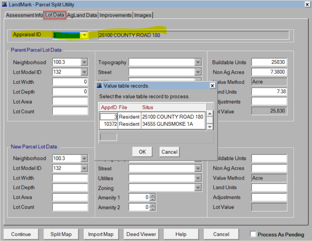
When doing a split, the value of the lot will be divided based on the unit that is transferring from the parent to child.
When splitting from a lot, CLICK the move button to transfer parent information to child’s.
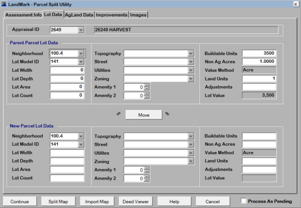
Splitting Acres into Lots: users can input Neighborhood and Lot Models to value the land.
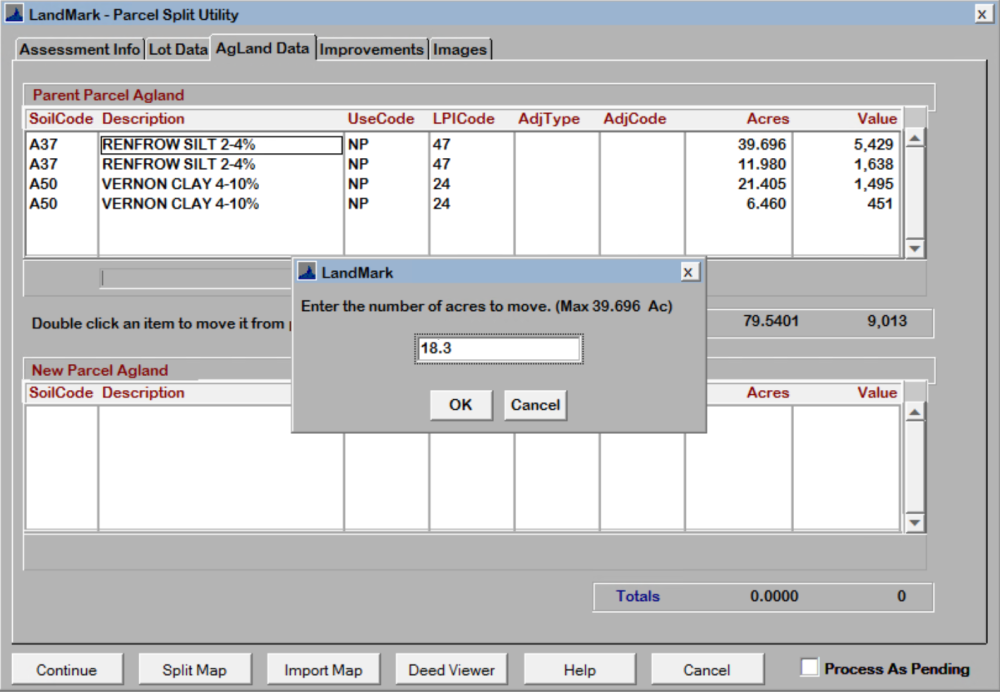
Ag Land DataTab
Shows the soil summary of the parent account.
When splitting on the map, the correct acreage of each soil will automatically be calculated and taken out from the parent. IF the Allocate Land Units box is checked near the bottom of the Assessment Info Tab.
If users wish to move soils manually, double click to move all soil or right click to move part of the soil. To undo follow the steps above.

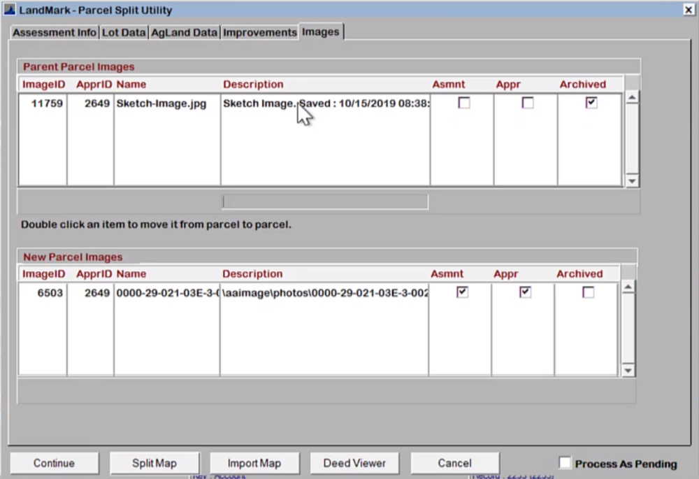
Improvements and Images Tabs:
If the parent account has any improvements or images that are to be transferred to the child account, users can double-click to move. Or double-click to move back. It is up to the users to enter this data before splitting on the map or after the split has been done.
New Construction
If there is new construction on the account and all the improvement value is moved to the child account the parent won’t have any new construction on the valuation summary tab.
To initiate the split on the map CLICK the “Split Map” button on the bottom.
This will open MapAnalyzer in Edit Mode on the Parcel Layer.
The parent account will be active and the user may not select another account on the map until the Split is applied or canceled.
If the COGO Editing option is checked in Editor Preferences under options, the Map will open the split by COGO.
If the user wishes to split by keyboard, select Split- Split by Keyboard.
When completed the system then clips the new shape from the parent parcel and updates the attributes data to match the parent.
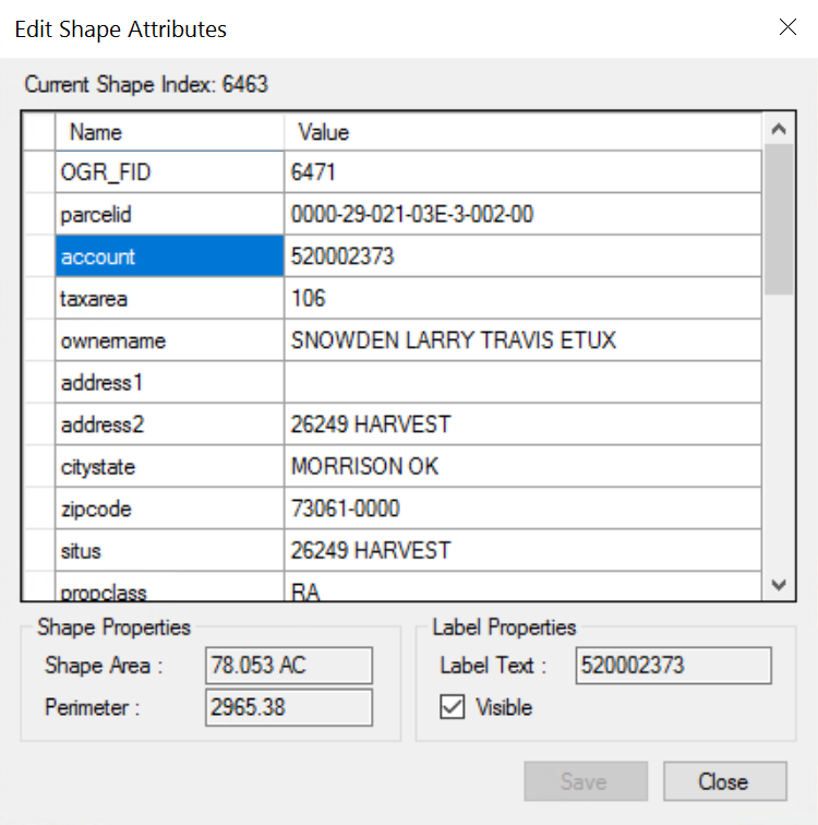
- If the split was initiated in LandMark, the account data will be the child account number.
- If the split was done from the Map, the user will have to manually link the new parcel with the account number by right clicking on the child parcel and editing the account number on the Edit
Shape Attributes table.
Example: Using COGO to create the new polygon.
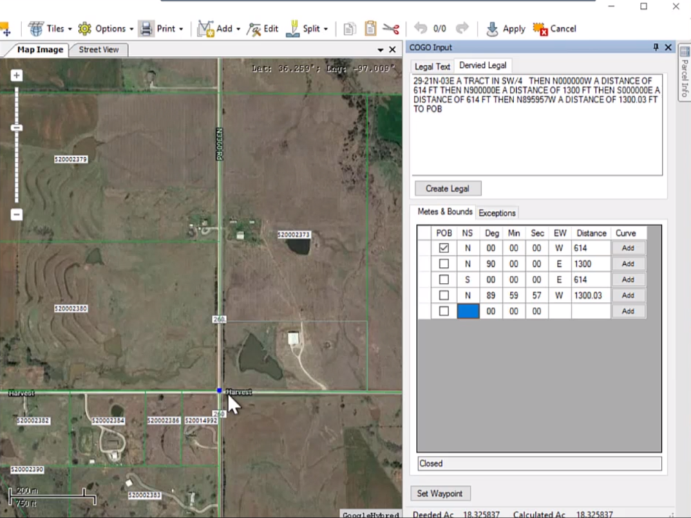
Notice the Legal Description data has been populated from LandMark.
SELECT the Parse Legal button to create the polygon from the legal text.
The new parcel is drawn on the map and zoomed to.
Important Note: When using COGO, MapAnalyzer uses the Section layer to locate where the parcel is in the county (as seen in this example) this doesn’t match exactly where the parent parcel is located. This can be rectified by dragging the points the correct location or by right clicking on the new polygon and selecting Align Vertices.

When the Align Vertices option is selected, MapAnalyzer will prompt for a Maximum Tolerance value, if a point is within this defined distance from an existing point in the parent shape, the parent point will be substituted. If no point is found the system will check to see if the point is within the tolerance of a boundary line and if it is, the point will be moved to the boundary.
When the new parcel has been defined:
SELECT the Apply button ![]() to apply the parcel split to the map.
to apply the parcel split to the map.
The system will clip the new polygon from the parent parcel and return the calculated land totals, including a new Ag Land Summary to LandMark.
After the split has been applied the land information both ag and non-ag are update with acreage and value.

MOVE improvements from parcel to parcel by double clicking on the item to move.


MOVE images from parcel to parcel by double clicking on the item to move.

SELECT Continue to complete the Split of the tabular assessment and appraisal data in LandMark.
When the tabular has been updated, MapAnalyzer will then display the new data in the Parcel Information panel.
Helpful Hint: After the Split, Read Appraisal Values and sell the parcel or work the deed.
Post your comment on this topic.