
As of February 2022, users can now use Eagle View’s imagery through a tile service.
To use this imagery the county must have contracted with Eagle View AND have been provided an API key as well.
Only MapAnalyzer admins can do the set up.
To set up the Eagle View imagery as a custom tile within MapAnalyzer:
SELECT Options – System Setup — Tile Settings (Tab)
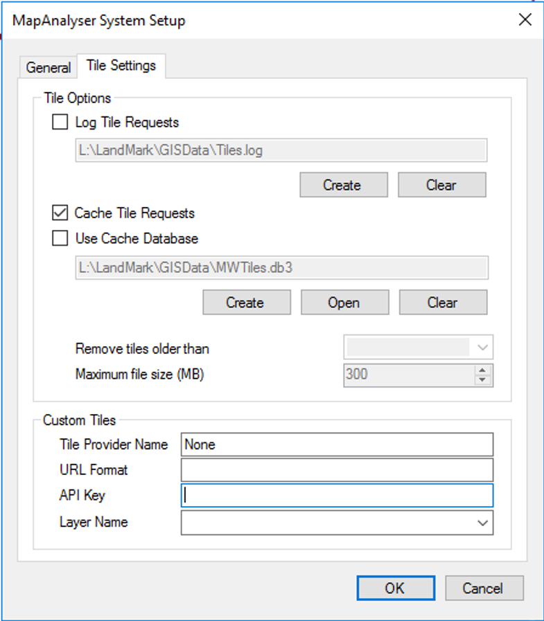
1. Title Provider Name
SKIP this box for now, as it will autogenerate. (See below.)
2. URL Format (This is the same for all counties and needs to be exactly as typed below.)
https://svc.pictometry.com/Image/{YOUR_API_KEY}/tms/1.0.0/{LAYER_NAME}/zoom/x/y.png
DO NOT PUT your county’s specific API Key or Layer Name within the brackets. TYPE or COPY and PASTE EXACTLY as above.

The API Key will be provided by Eagle View.
The example below, shows Bryan County’s: B6839282-05FE-A4A8-1AF6-F61180B54A86

3. Layer Name
Once the URL Format and API Key are populated, the Layer Name field will be enabled.
DROP-DOWN list and SELECT a base layer.

These layers will be all of the Eagle View fly-overs that have been done.
This layer can be changed at anytime and the tiles will come from this layer.
This can be used to view historic imagery. (By choosing a different layer name.)
5. When Layer Name has been chosen, Title Provider Name will be updated with the abstract data associated with the imagery.
User may edit the Title Provider Name to whatever suits them. (Example below is autogenerated.)

CLICK OK to finish set up.
SAVE ![]() MAP STATE!!!
MAP STATE!!!
Another Example: McClain County the custom tile setup would look like this:

As you can see there are two available layers, one in 2016, that is only the Norman metro area and the other is a county wide mosaic completed in 2020.
This is a list of all the counties LandMark has received an API Key for, from Eagle View, and has configured the county’s MapAnalyzer Custom Tiles.
Atoka County
333D4EC4-4144-9855-C16F-F17438DE2390
Bryan County
B6839282-05FE-A4A8-1AF6-F61180B54A86
Caddo County
3E8B19D2-EEEF-7066-A24D-8CDD5A3EF507
Comanche County
953C054F-F7C8-2D77-0829-CEA34BEE4388
Garfield
AAD72DA4-B1C8-DDCA-DE2F-773BEB8F5EA5
Johnston
0BE78B7B-06A4-377C-C7F9-CC318EF29541
Kay County
E1305EA5-03FD-0527-FE0A-299603D5826F
Love County
EB123C24-0777-8588-D0A4-9D37A9730EFA
Major County
CF461B76-5B44-C2F5-CECC-1E9C284062DA
McClain County
81C1A788-A9B9-B6D9-B9E0-95C2F06DF631
Muskogee County
43A57663-1ED3-E1AC-7608-157B6ABA6238
Below is the shared URL (for all counties). See #2 above.
https://svc.pictometry.com/Image/{YOUR_API_KEY}/tms/1.0.0/{LAYER_NAME}/zoom/x/y.png
Users can see all of a county’s available layers and their abstract information in a regular browser by using this URL and substituting the highlighted section with the county specific API Key.

This URL is for McClain County and will return the following Image Data:
CONNECT Image Service: WMS
——————————————
This is the Pictometry CONNECT Image Service WMS Endpoint. Available layers to this account:
Title: OKMCCL20 (McClain)_OM (2020 Pictometry Mosaic) Name: PICT-OKMCCL20-kt4trc8hFT Abstract: Capture dates: 01/23/2020 – 05/09/2020, Copyright Pictometry 2020 Min Latitude: 34.85044337232 Min longitude: -97.735056800291 Max latitude: 35.347610777482 Max longitude: -96.924824791506
Title: OKXNOR16 (Norman Metro)_OM (2016 Pictometry Mosaic) Name: PICT-OKXNOR16-P6jT2ybM20 Abstract: Capture dates: 02/01/2016 – 02/29/2016, Copyright Pictometry 2016 Min Latitude: 34.82676840864 Min longitude: -97.759090089529 Max latitude: 35.504841120315 Max longitude: -96.582183837891
Use this endpoint with any software that accepts a WMS 1.1.1 or WMS 1.3.0 service.
Information about Pictometry & CONNECT can be found at www.pictometry.com.
For Customer Technical Support contact: customersupport@pictometry.com
Post your comment on this topic.