
MapAnalyzer’s Coordinate Geometry “COGO” input form allows the user to create a new polygon either by entering the metes and bounds data or by entering a legal description and having the system generate the survey calls from the legal text. The Add by COGO tools can be use used to create polygons in the Subdivision, Lot or Block layers.
DEFINITIONS
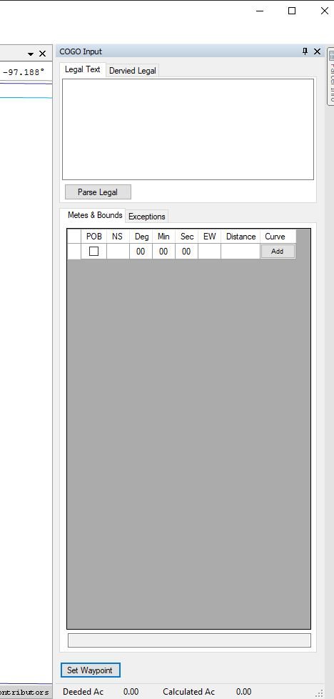
Legal Text: This is where the user can paste the legal description of the parcel being added.
Derived Legal: As users input the metes and bounds data, Map Analyzer builds a legal description for the account being created.
Parse Legal: This button take the legal text and creates the calls under Metes & Bounds. If it is a rectangular survey it will draw it on the map.
Metes & Bounds: Users will place there calls under the columns the legal falls under
- POB: Point of Beginning, users will check this box at the call the polygon will begin.
- NS: North and South directions for the call, user will enter a N or S in the column.
- Deg: The degrees in which the said call is going, this ranges from 0-90.
- Min: The minutes of the call, this ranges from 0-59.
- Sec: The seconds of the call, this ranges from 0-59.
- EW: East and West direction, users will enter a E or W in the column.
- Distance: How many feet the call is going. Users only need to enter the numbers.
- Curve: users can hit the add button to add any curve parameters.
Exceptions: Users can add the less and excepts from the parcel being drawn here.
Set Waypoint: This allows users to place a point on the map from where the call is commencing or beginning.
Adding By COGO
CHOOSE Layer to edit
ENTER Edit Mode
SELECT Add — Add by COGO in the Toolbar
The Parcel info panel on the right side of the map will now display the user’s COGO Input.
ZOOM map to the correct location
SELECT the Set Waypoint button in the bottom
The cursor will turn into a plus sign.
This allows the user to set the reference point for the survey data such as: the NE Corner of the SW1/4.
Survey calls can be added from this waypoint to get to the Point of Beginning or this could also be the Point of Beginning depending.
CLICK on the map to select the point. The waypoint will be displayed on the map as a grey diamond.
MapAnalyzer will use the Snap to Vertex setting in the Editor Preference to locate the point.
CHECK the POB (Point of Beginning) box to indicate the survey call is to the first point in the polygon.

ADD the survey calls
The Derived Legal tab will contain the legal text of the survey calls. The Derived Legal does not contain the Section-Township-Range and has to be added by the user.
This text will automatically be copied to the user’s keyboard.
CREATE LEGAL button will show the new parcel on the map.
If the parcel split was initiated in LandMark, selecting the Create Legal button will update the child accounts legal description text in the LandMark Split Utility.

Notice that the distances displayed on the map are adjusted for the curvature of the earth.
Post your comment on this topic.
MONTA BROWN wrote: Apr 21, 2020
YOU ROCK RANDI!!! THIS IS AWESOME EVEN I CAN UNDERSTAND THIS! GREAT JOB!!