
Assessment Data tab is the first tab in the Assessment Record or Parcel File
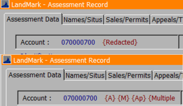
Account messages will show in the upper right corner of the Assessment Record. Messages that may appear are: Deleted Account, pending active account, inactive account, pending inactive account, inactive account, advance taxes, pending class changes, fractional ownership, linked ownership, and cross-referenced account source. 
Main Menu — Assessment — Parcel File
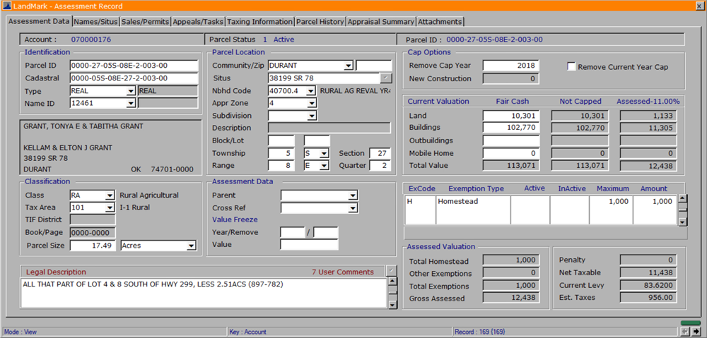
- Account: This is a system assigned number prefixed with the OTC’s County ID Number.
- Labels: Words or letters in red {} next to the account number signify a label on the account.
- Redacted means the name ID has been hidden or redacted.
- A signifies the account has an alternate Mailing ID
- M Mortgage on the account.
- Ap Appeal on the account.
- Multiple Multiple names in the ownership table.
- Parcel Status: This shows the accounts current status. Click here to view how to edit the Account Status.
- Parcel ID: This is a formatted geo-referenced field and the format is set on the County Information Table. This field can be customized to the County’s discretion.
Identification Group:
- Parcel Status: This is where the Parcel ID would be entered or edited.
- Cadastral ID: This is a user assigned number and its format is defined in the County Information Table.
- Type: The Type field determines how the property is assessed: real or personal, subject to penalties, caps or exemptions. Options for this field are defined in the Source Table. Type is a mandatory entry field for any account.
- Name ID: The Name ID links an Owner’s name and address to the parcel. *This is also a mandatory entry field for any account. View the Name ID Module for more information.
Classification Group:
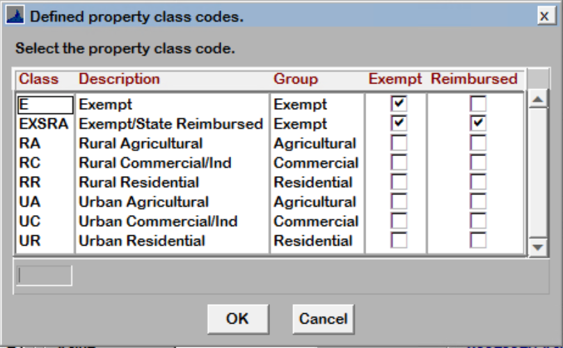
- Class: The Class Field determines the OTC classification of the parcel and is used in generating the abstract or exempting the property. This is a mandatory entry field and the options are defined in the Property Class Table.
- Tax Area: The Tax Area Field determines the levies that will be associated with the parcel. The taxing authorities associated with the Tax Area Code are listed in the Est Taxes Field.
Note: These Tax Area’s are more commonly referred to as School Districts in most Counties. They are considered Tax Area’s in the LandMark System because they encompass more than just the school districts. The County’s original School Districts are listed as a Cross Reference Code in the Tax Area Table. To view all the taxing districts associated with the tax area, go to the Tax District Table:.

If user selects a deleted area for an account, this message will appear.

This will have to be corrected before going to the next field.
If users tries to delete a tax area that is being used on accounts or public service accounts, this message will appear.

- TIF District Field: The Tax Increment Financing (TIF) District assigns the parcel to a project defined in the TIF Module
- Book/Page: Deed book and page.
- Parcel Size Field: The Parcel Size is a user entered value representing the acres, lots or square-footage of the account.
Parcel Location Group:
- Community/Zip: The community is the town in which the property is located and the zip code where the parcel sits.
- Situs: This is the physical street address of the parcel.
- Neighborhood Code: This is a user assigned code that groups properties subject to similar market forces and determines which visual inspection zone a parcel is in.
- Appraisal Zone: The appraisal zone represents the Visual Inspection Area. If user wants to make this field editable, see check box Input Appr Zone guidance in the County Information Table.
- Subdivision Code: If the parcel is platted, this is the subdivision code associated with that subdivision.
- Block/Lot: This is the subdivision lot and block where the parcel is located.
- Township: This is the township number where the parcel is located along with a township direction.
- Range: This is the range number and direction where the parcel is located.
Assessment Data Group:
- Parent: This field is automatically populated by the split routine and lists the parcel’s parent account.
- Cross Reference: This field is used to link Personal Property accounts to Real Estate Accounts where the personal property is located.
- Value Freeze Options: This is the senior freeze field where valuations are frozen for qualifying applicants. LandMark will automatically add new construction on top of the senior freeze at the end of each tax year. When entering a freeze year, the value calculated will take into account the homestead exemption that should be added to the account. Running Process Pending Accounts (after Tax Roll is complete) will automatically update accounts going on or off.
Legal Description Box: This is an unlimited, free text legal description of the parcel. By clicking the check mark in the upper right corner of the box, the legal description can be edited in a notepad text editor.

Cap Options:
Here a cap can be removed for either a current year, a future year or for both. These fields can be populated automatically based on the sales.
Remove Cap Year The year the cap will be removed.
Remove Current Year Cap Check to remove current year cap.
New Construction If there is New Construction listed in the Appraisal Side for the current year, it will show here.
Current Valuations Section:
Values will be broken down or allocated over land, buildings, outbuildings, mobile homes and total values.
Outbuildings (new 6/24/2023) no values will show here until after the VI area has been updated in that county and/or the values have been rolled from appraisal to assessment.
Fair Cash This is where the current market value is located and cannot be edited.
Capped The capped fields are automatically calculated based on prior year value and new construction and cannot be directly edited.
Assessed w/ Assessment Percentage) This is the total assessed. If NOT capped it’s figured by taking Fair Cash * The County’s Assessment Percentage (11% in this example). If CAPPED it’s figured by taking Capped Amount * The County’s Assessment Percentage (11% in this example).
IF the account has personal property on it, the Current Valuations section appears differently.
Values will be broken down into leasehold, schedule, inventory, mobile home and total value.

Exemptions Table: All exemptions are added through the exemptions table including: homestead, veterans, storm shelters and Freeport.
Assessed Valuation Section: Here the capped values are multiplied by the county’s assessment level and subtracted of any exemptions to get the total taxable value.
- Est Taxes: These are the estimated taxes based on the Taxing Area.
Post your comment on this topic.