
To open the source table from the Assessment File, go to:
View – Tax Calculation – Source Table
The Property Source Table is where each property type is defined and allows for users to select a rendition form and valuation notice as well as set the cap increase amount and assessment level for each type of property.
Source Setup Tab
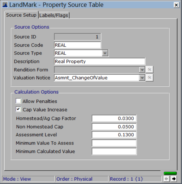
Source Options Fields:
- Source ID: This is a system assigned table ID number. This is a non-editable number.
- Source Code: This is a unique name assigned to a predefined list of source types and is county defined. The source code must be linked to a property type of either Real, Personal or State Assessed.
- Source Type: This field can be selected from one of three types: Real, Personal or State Assessed.
- Description: This is a user defined field to describe the property identified by the source code.
- Rendition Form: Users can select rendition forms to go with each type of property. For example, Business accounts should have a 901 Rendition associated with them while Petroleum Business accounts should have a 901-P associated with them.
- Valuation Notice: Users can select valuation notices to be associated with each property type as well. For example, Personal Property should typically have a 926-P valuation notice, while Real Property should typically have a 926 valuation notice.
Calculation Options Fields:
- Allow Penalties: If this box is checked, penalties will be allowed on this type of property. If not checked, then penalties will not be applied to the property type.
- Cap Value Increase: If this box is checked, the system will automatically calculate a cap value on the property type.
- Homestead/Ag Cap Factor: If the Cap Value Increase box is checked, homestead and ag properties will increase by the factor number in this field. This number will typically be at 0.03 or 3%.
- Non-Homestead Cap: If the Cap Value Increase box is checked, all non-homestead and non-ag properties will increase by the factor number in this field. This number will typically be at 0.05 or 5%.
- Assessment Level: This is the County’s assessment level and can be defined for each type of property.
- Minimum Value to Assess: Users can set a minimum value for the system to assess.
- Minimum Calculated Value: Users can set a minimum value for the system to calculate. For example, if this field is set to 100, any value between 1 to 100 the system will automatically calculate the value at 100.
Labels/Flags Tab

- Valuation Label Fields: These are the field label names that will show on the Current Valuations section of the Assessment Data tab of the Parcel File.
- Misc Assessment Flags: These are the field label names that will show on the Assessment Flags fields on the Taxing Information tab of the Parcel File.
Feedback
Copyright © 2025 LandMark GSI
—
Powered by 
Post your comment on this topic.