
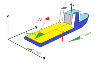
The GPS position is the position of the antenna. However, at the instant the position is taken, the vessel will have a given heading and may also have a pitch and roll angle. These are observed with gyros and
accelerometers and the offsets to any point of interest can then be converted from the ships reference where X, Y and Z are starboard, forward and above keel draft to a shift in real world coordinates in East, North
and Height above sea level. For this to be done accurately, the offset distances need to be correctly tape measured or taken from accurate drawings and the vessel motion reference unit (MRU) has to be accurate in
pitch roll and heading. For long offsets this can add another meter or two of uncertainty depending on the vessel size.
It is important that the marine survey report includes a section on expected accuracy of offset calculations based on the instruments and measurement methods used. This information should be submitted to the SFP
and be understood by the SFP. A simple sign convention error on offsets can translate into a very significant subsea positional error.
Post your comment on this topic.