
The purpose of calibration is to evaluate the coefficients for the various ‘error’ terms described above. Having established the performance figures or ‘characterised’ each sensor, any systematic errors may be compensated thus enhancing its accuracy.
To achieve this, the survey tool is placed on a calibration stand which allows the tool to be rotated between a series of known fixed orientations with respect to the local geographic axis set defined by the directions of true north and the local gravity vector. At each position, the turn rates and accelerations to which the sensors will be subjected in each controlled position are very accurately known. The series of positions are selected to excite each error contribution and so allow each error term to be identified separately and evaluated.
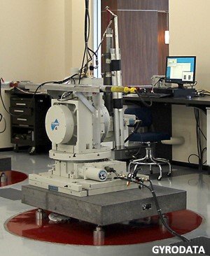
The highly accurate, custom made calibration stands used for this purpose were designed and developed by Gyrodata. Each calibration stand comprises a stabilised gimbal system with precisely controlled and instrumented gimbal angles. The stands are mounted on a plinth of granite that has its own foundations separate from, and vibrationally isolated from, the laboratory. The stands are aligned to true north within 0.001 degrees and are able to rotate the tool to any angle of inclination, azimuth or tool-face to an accuracy of 5 arc seconds (5/3600 degrees).
Post your comment on this topic.