
One of the most important lessons in geodesy is the next step. How do we tie the ellipsoid to the real world? Now that the model is set up, we have to attach it to the real world. Here is the definition of a ‘Geodetic Reference Datum’:
A Geodetic Datum is an ellipsoid of revolution attached to the Earth at some point. There are two types:
| Astro-Geodetic | (Regional usage) |
| Global | (Global application) |
We move from simply an ellipsoid, ‘floating’ in space to a ‘geodetic reference datum’. There are two valid ways to do this, the historic, astro-geodetic (regional), pre-navigation satellite days method and the global method using satellite orbits.
Below shows how an astro-geodetic datum is established. Astro-geodetic means the geodetic system is set up by direct observation of the stars using very specialized survey instruments. The surface origin is the place where the survey instrument is set up.
The ellipsoid is attached at the observation point and several ‘alignments’ have to take place mathematically:
The equatorial plane of the ellipsoid has to align with the physical equatorial plane
The Polar Axis of the ellipsoid has to be parallel to the physical polar axis of the Earth
The ellipsoid surface has to be positioned so that it matches as closely as possible to the Geoid over the area of interest

On above 6, note three significant issues:
- Astro-geodetic (geoid referenced) latitudes are not quite the same as geodetic (ellipsoid referenced) latitudes. This due to the slight difference in the normal to the respective surfaces. This is the model ‘distortion’ due to using an ellipsoid. If the region covered is a continent like the USA or Russia, then as the datum network is spread across the land then least squares corrections called ‘Laplace’ corrections have to be made to minimize the distortion.
- They take much time to observe under demanding accuracy conditions which can be affected by the weather.
- They are subject to the observation idiosyncrasies of the observer. Relative accuracy between datums established in the same place by different observers can be several hundred meters.
The drawback of the astro-geodetic method is that it is only useful over a specified region, and in general cannot be carried across large expanses of impenetrable terrain or water, since inter-visibility is required. Thus in archipelagos, like Indonesia, this can result in a large number of small regional datums none of which quite match with the others. Political boundaries can also mean a multiplicity of datums even in contiguous land masses; West Africa is a good example, where each country has its own unique astro-geodetic datum. Below shows a global view of continental regional datum ‘blocks’. Eight datums to cover the world does not seem so difficult, but in fact there are well over 100 unique astro-geodetic datums as can be seen from datums in SE Asia.


A global datum is a datum that is established to model the entire global geoid as closely as possible; something an astro- geodetic datum cannot do. A global is datum is established by observing the orbit of navigation satellites, calculating the Earth’s centre of mass based on the orbits and then adjusting the ellipsoid by harmonic analysis to fit the global geoid. There have been several variants, but the two primary ones are WGS 72 and WGS 84. WGS stands for World Geodetic System. The WGS 72 datum was established for the ‘Transit Doppler’ satellite system, WGS 84 was established for the GPS system. The ‘connection’ point or origin for the global datums is the Earth’s centre of mass. Due to iterative improvement of the gravitational analysis, the centre of mass is slightly different for WGS 72 and WGS 84.
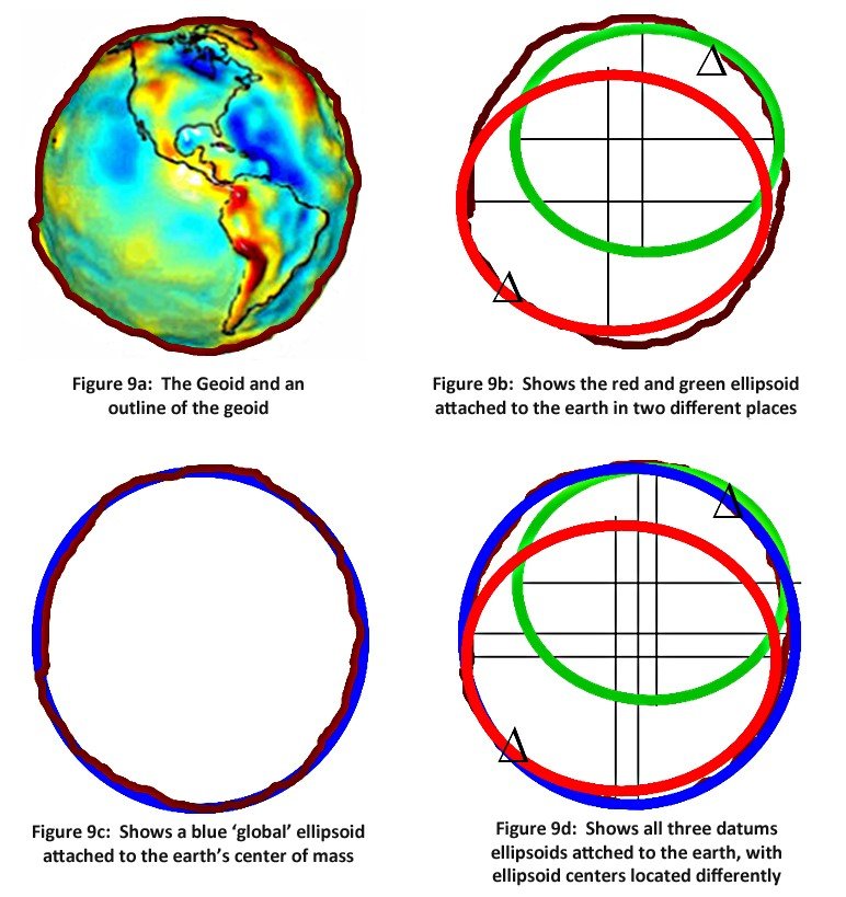
Figures 9a through 9d show, in cartoon form, the juxtaposition of two astro- geodetic datums with the geoid and a global datum. In figure 9a we see the geoid. There is an outline for representation in the other figures. In figure 9b red and green astro-geodetic datums are shown connected to the surface at two different points. The differences are exaggerated for effect. Figure 9c shows the geoid and the global datum. Figure 9d shows all three ellipsoids juxtaposed with the center of the ellipsoids clearly shown in three different places (again exaggerated for effect). Since latitude and longitude are referenced to the centre of the respective ellipsoid, it is clear that a latitude and longitude on one datum will not be compatible with a latitude and longitude on another datum unless some sort of transform takes place to adjust the one to match the other.
Reference Datum Transformation: Below figure shows a global (blue) and an astro-geodetic or regional datum (green), with the offset of the two centres. In order for a coordinate on the blue datum to be transformed to the green datum, the latitude and longitude have to be converted to x,y,z Cartesian coordinates on the blue datum. The dx, dy, dz have to be applied giving the x,y,z on the green datum. This can then be converted back to latitude and longitude on the green datum.


Numerically these two sets of coordinates will be different but they will continue to represent the same physical point in space, as can be seen in figures above. The corollary is that coordinates referenced to one datum that are mapped in a different datum will appear in the wrong place! The reader should note that in some of the larger regional datums, there are a variety of 3 parameter datum transformation sets depending on where in the region the operator is working (below).

These are captured in the EPSG parameter database. Note also there are more sophisticated methods of calculating the datum transformation which may appear in various applications. These include parameters that not only translate but also allow for rotation and scaling differences between the two datums. The EPSG parameter database also contains many of these. Care should be taken when applying such parameters, and it is best to obtain the services of a specialist when using them or coding them into software. For most applications in the E&P domain, a three parameter shift will provide the necessary accuracy. In some countries more elaborate parameters are required by law.
Post your comment on this topic.