
This is a overview of LandMark GSI Land Valuation Training May 13, 2020 .
Using Tables to Value Land May 13, 2020
This training covers:
- 0:00-10:33 — Lot Model Table portion
- Neighborhood Table portion
- 10:33-15:54 — Topography, Street Access and Utilities Adjustment Example Using Default Types of Amenities
- 15:54-19:30 — Amenities to the Land Example Using User Defined Types of Amenities and Adjustments
- 19:30-27:01 — Amenity 1 and Nbhd Amenity 2 Examples (Shape, and Lake Frontage Models)
- 27:01- 40:12 — Applying Neighborhoods, Changing a Neighborhood from Lot Valuation Model to Square Feet Method, Updating Lot Sizes
- 40:12 – 41:03 — Overriding the Lot Value
- 41:03 – 45:53 — Using Lot Model and Neighborhoods in conjunction with Ag Land
- 45:53 – 48:37 — Using the Map to Define Neighborhoods
- 48:37 – 54:15 — Land Conversion Issues
- 54:15 – 57:10 — Mass Updates for VI Area Neighborhoods
- 57:10 -1:01:10 — NonAg Home Site Values Example: How to separate the home site from Ag Land Table
- 1:01:10 -1:02:55— Cleaning Up double land records from the conversion
- 1:02:55 – 1:08:39 — Ag Land— Soils
- 1:08:39 -end — Front Foot Model Example
General thoughts on Neighborhood Table Adjustments
- In mass appraisal uniformity is important. Adjustments from a Land Table help make equality across the board than individual parcel adjustments.
- Neighborhoods can now span VI Areas.
- Lot Models can span multiple Neighborhoods, but must be linked to the Neighborhood.
- If user doesn’t define an adjustment, they won’t get an adjustment.
- In each Neighborhood, user may have a land factor that would ONLY affect this Lot Model in that Neighborhood.
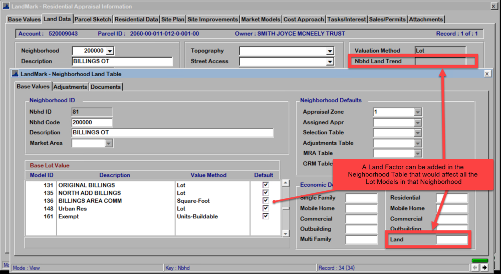
Helpful Hint: When user makes changes in the Neighborhood Table, it DOES NOT change the land values in the Land Data Tab. User must make an Index for that Neighborhood. In the Index go to Tools — Recalc File and that will apply the updated Model to the Index.
Topography, Street Access and Utilities Adjustment Example
Using Default Types of Amenities
To view teaching on video go to 10:33-15:54
To view or edit the Neighborhood table from the Appraisal Module, go to Tables — Land Tables — Neighborhoods

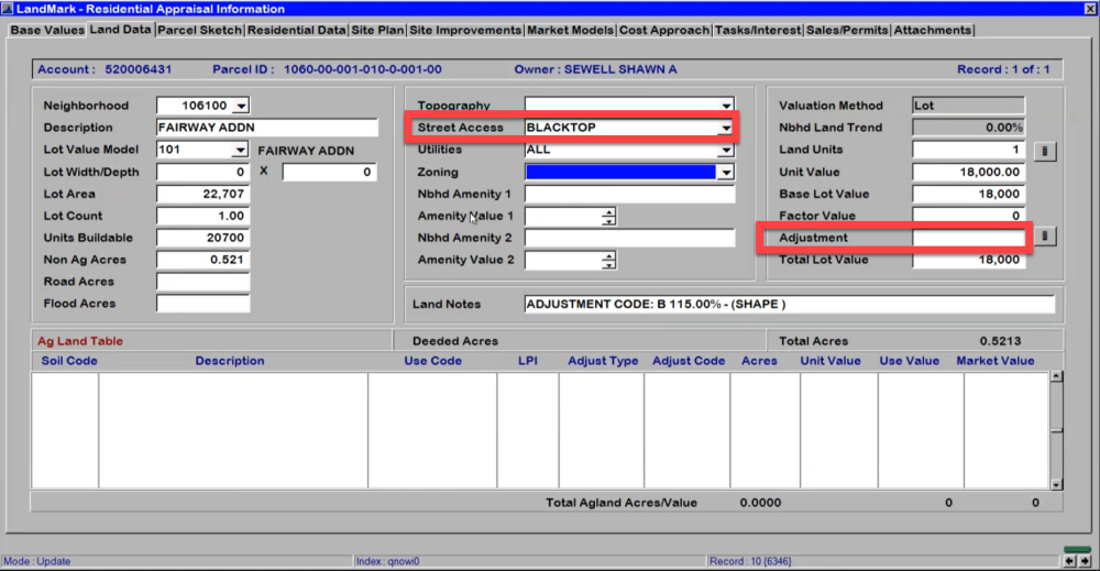
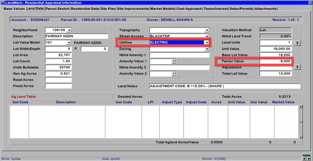
In the Land Data Tab (Edit Mode) user can click the down arrow to view the options. Each option may have an adjustment tied to it.


To define adjustments go to Tables — Land Tables — Neighborhoods

Notice how the definition of amenity changed the values.
If user DOESN’T define an adjustment— they WON’T get an adjustment.
In the example below: Concrete wasn’t defined, therefore no adjustment. Also, Rural Water, Electric Septic wasn’t defined, so there will be no adjustment.


Other Amenities to the Land Example
Using User Defined Types of Amenities and Adjustments
To view teaching on video go to 15:54-19:30
In this example, the user defined their own types of amenities and adjustments.
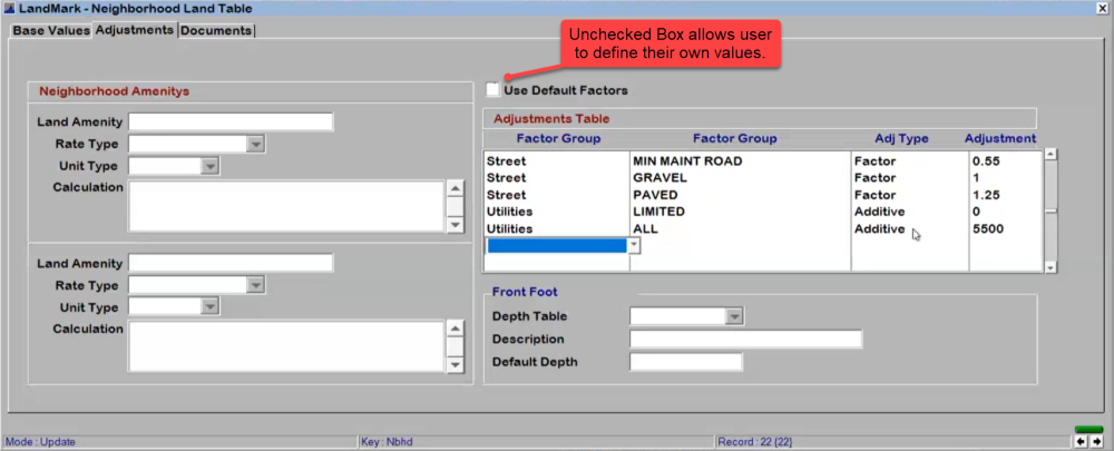
Now in the Land Data Tab (in edit mode) when user clicks the down arrow they will only see the definitions they created.


Notice how the values change according to the amenities.


Nbhd Amenity 1 and Nbhd Amenity 2 Examples
To view teaching on video go to 19:30-27:01
Go to: * Neighborhood Table — Adjustments Tab — Neighborhood Amenities*
This example will show a Shape (using different levels of adjustments) and Lake Frontage (using front feet) Neighborhood Amenity.
Here is the breakdown of the Shape Amenity.

This is how it appears in Land Data tab.

To build a linear foot adjustment such as lake frontage user can build the table as follows.

This is how a front foot adjustment will appear in the Land Data Tab.

Post your comment on this topic.