
Direction of Buoyage
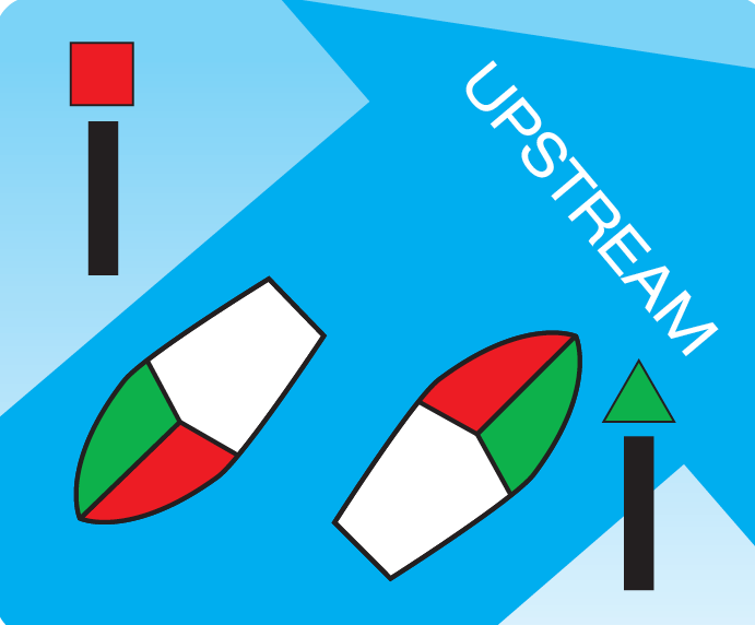
In order to navigate safely it is essential to know the direction of buoyage. On all waters, buoyage runs east to west and from seaward inwards to ports, harbours, rivers, estuaries and other waterways.
When leaving a port, harbour, river, estuary or other waterway the port hand mark (red) should be passed on the vessel’s starboard (right) side. Upon entering a port, harbour, river, estuary or other waterway the port hand mark (red) should be passed on the vessel’s port (left) side.
You need to know the direction of north and the other main points of the compass.
It is an offence for any person to interfere or tamper with, or obstruct the use or operation of, a navigation aid.
IRBs cannot operate before first light or within 30 minutes of last light. Any operations outside of these times will require state approval and the relevant boating requirements must be adhered to.
Lateral marks
These are used to indicate the port (left) and starboard (right) sides of the channels when travelling into port.
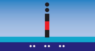
Port hand marks
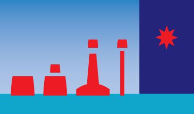
These are red and the basic shape of the buoy (and top mark when fitted) is cylindrical (a can). Such a mark would be on the port (drivers) side of a vessel when travelling in the direction of buoyage.
Colour: Red
Lights: Red (when fitted) and may have any rhythm other than composite group- flashing (2+1). They are used on modified lateral marks to indicate a preferred channel.
Starboard hand marks
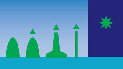
These are green (occasionally, black may be used) and the basic shape of the buoy (and top mark when fitted) is conical. This mark would be on the starboard side of a vessel when travelling in the direction of buoyage.
Colour: Green
Lights: Green (when fitted) and may have any rhythm other than composite group-flashing (2 +1). They are used on modified lateral marks to indicate a preferred channel.
Cardinal Marks
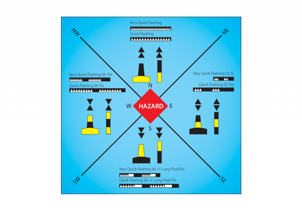
These are used to indicate the location of the best navigable water, to show the safe side on which to pass danger (rocks, wrecks, shoals, etc.) and to draw attention to a feature in a channel.
To understand the meaning of a particular cardinal mark, the navigator must be aware of geographical directions and therefore needs a compass to determine where the best navigable water lies.
The mark is placed in one of the four quadrants: north south, east or west. If in doubt, consult the chart.
Colour: Black and yellow horizontal bands are used to colour the cardinal marks and indicate the type of cardinal mark. Top mark cones point in the same direction as the location of the black bands on the marks.
Lights: If lit, the mark will exhibit a quick flashing (about 1 per second) or very quick flashing (about 2 per second) white light. The rhythm of the light will indicate the particular quadrant of the mark.
The number of flashes corresponds to the numbers on a clock face:
N – continuous
E – 3 flashes
S – 6 flashes and one long flash
W – 9 flashes
North cardinal mark
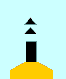
Pass on the northern side of this mark.
Topmark consists of two cones pointing up.
Colour: The mark has a black band over a yellow band.
Light: When lit, a north mark exhibits a continuous quick or very quick flashing white light.
East cardinal mark
Pass on the eastern side of this mark.
Topmark consists of two cones pointing away from each other.
Colour: The mark has black/yellow/ black bands.
Light: When lit, an east mark exhibits a white light flashing in groups of three quick or very quick flashes.
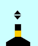
South cardinal mark
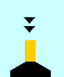
Pass on the southern side of this mark.
Topmark consists of two cones pointing down.
Colour: The mark has a yellow band over a black band.
Light: When lit, a south mark exhibits a white light flashing in groups of six quick or very quick flashes followed by a long flash.
West cardinal mark
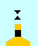
Pass on the western side of this mark.
Topmark consists of two cones point to point.
Colour: The mark has yellow/ black/yellow bands.
Light: When lit, a west mark exhibits a white light flashing in groups of nine quick or very quick flashes.
Isolated danger marks
These are on, or moored above, an isolated danger of limited extent that has navigable water all around it.
Colour: Red and black marks
Lights: If lit, the light will be white showing a group of two flashes. It may help to remember this mark by associating the two flashes with two spheres.
Special marks
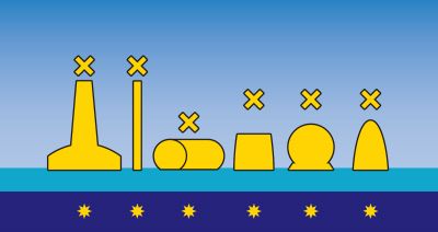
These are used to indicate a special area or feature, the nature of which may be found by consulting a chart or sailing directions.
Lights: If fitted it will be yellow and may have any rhythm not used for white lights.
Safe water marks
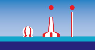
Colour: Red and white marks
These are used to indicate that there is navigable water all around the mark. These marks can be used as a channel entrance, centre line, mid-channel, or landfall buoy